Posts Tagged Highest Peaks
Life Elevated
Posted by Deb in Full Time RV, Highest Peaks, Hiking, Running, Trail Run, Ultra Running on December 4, 2019

We’ve been bouncing around above 6000’ since May. The warmer the temps the higher we go.
That’s the beauty of living mobile. Too warm, move north or to a higher elevation. Too cold, time to head south and back to sea level.
Las Vegas, NV (Elevation: 2,001’)
We started our spring in Las Vegas for the Mt Charleston Marathon and Half Marathon. Our running group from NW Arkansas was bringing around 100 folks to the event. Since we needed to be in Vegas for the National Hardware Show about that time it only made sense to join in on the fun!

We arrived in Vegas about a week before the event and made a trip out to Red Rock Canyon for a training run. We’ve never been fans of Las Vegas, but the Red Rock Canyon could certainly change our minds. Spectacular red canyon views, safe roads for cycling and tons of trails to hike or run. It is certainly a special place!

Red Rock Canyon
The Mt Charleston race was a fun but very hot race. What made this event enjoyable was the route was completely downhill.
Busses transported us up to Mt Charleston in the wee hours of the morning. Temps were cold when we started. But by the time we crossed the finish line people were dropping like flies from the heat. So many people needed medical help that the race has now been moved a week or two earlier to try to avoid another disaster.

Mt Charleston Marathon and Half Marathon
Williams, AZ (Elevation: 6,700’)
As the temperatures were already getting into the 90’s in Vegas we moved to Williams, AZ. We had a week until we needed to be in Flagstaff for Overland West Expo, so we picked a new BLM site to kill some time.
Big open meadows to camp and plenty of trails for running, all within a few miles of the quaint little town of Williams.

Another trip down into the Big Ditch
Williams is on Historic Route 66 and is considered the Gateway to The Grand Canyon and houses the southernmost terminus of the Grand Canyon Railway. Williams was considered the last holdout for Hwy 40 to bypass Route 66.
We made a quick trip to the Grand Canyon for Easter Sunday sunrise service and stuck around for breakfast at the Bright Angel Lodge. The Grand Canyon is always special no matter how many times we have been there.
Farmington, NM (Elevation: 5,393’)
After Williams and Flagstaff, we decided to move on to New Mexico. We haven’t spent time here, except to get from Arkansas to Arizona. We kept hearing about a BLM campground in Farmington, NM that just opened.
We thought we were beyond frigid temperatures, but the closer we got to Farmington the more unsettled the weather. Rain turned to sleet and snow and when we turned onto the dirt road for our final 3 miles to the campground, we were not sure we could make it. Thank goodness for 4-wheel drive, because without it we never would have made it to the muddy dirt road to Brown Springs OHV Recreation Area.
As we pulled in we were greeted by 4 of our fellow Xscapers RV Club members. Not knowing they were there, it was a nice surprise to see them! One thing we have learned after 4 years of full-timing, we usually run into someone we know.
We had a cold and rainy start to our stay, but the clouds moved out and the temperature rose over our 14-day stay.

Snowy start to our stay
This first come first serve campground is completely free with 11 designated campsites and pit toilet, but no hookups or dump station. Each site was beautifully landscaped with fire pit and covered picnic tables. The grand opening of the campground was the week before and only filled up over the weekends.

Beautiful large campsite
There are OHV trails all over this place and we enjoyed trail running to our heart’s content. One downside was the OHV activity, especially over the weekends, which brought in a ton of loud folks who didn’t feel it necessary to pick up their trash. Every trail run we went on we picked up as much trash as we could carry. Mostly alcohol bottles and cans littered the trails. Occasionally responsible adults threw out the kid’s juice bottles too. You want to start them young, right?

Tons of hiking right from the campsite
If you make it to Farmington be sure to plan a trip to Bisti/De-Na-Zin Wilderness Area 50 miles south, also known as the Bisti Badlands.
The unique landscape looks alien in nature, and is like nothing we have ever seen. We saw fossils, hoodoos, petrified wood, dried lake beds and the famous “cracked eggs”. It’s definitely worth a day trip to explore this expansive area accessible only on foot!

Cracked Eggs


Taos, NM (Elevation: 6,969’)
After Farmington, we moved on to Taos, NM. Taos is a charming little town with a rich history of conquests, revolts, raids, treaties, and wars. Finally becoming a US territory in 1850 and a state in 1912 it is now home to a booming art community.
We took a trip to the Rio Grand River Gorge that carves an amazing canyon into its flat landscape just west of town. Little specks of rafters could be seen from the top.

Rio Grand River Gorge
Crossing over the Gorge we also toured the eco/self-sustaining community called The Earthship Biotecture. They specialize in solar, water catchment and recycling and walls made of dirt-filled tires and glass bottles. Water was first captured from rain and snowmelt to be used from showers and washing dishes. This wastewater was then used to flush toilets then filtered to provide water for drip irrigation systems in greenhouses to water plants and vegetables.
It was an impressive, completely sustainable community.

The Earthship community
While in Taos we planned on hiking the highest peak in NM, Wheeler Peak at 13,159’. But inquiring at the local Outdoor store, we learned the Wheeler Peak was still covered in late season snow. Instead, we opted for the more elevation friendly Devisadero Loop Tail just on the edge of town. It was an easy 5.7-mile loop and had beautiful views of Taos.

Devisadero Loop Tail
While in Taos we stayed at the quaint Hotel Luna Mystica. Hotel Luna is actually a vintage RV rental “hotel” with a dirt parking lot in back for dry RV and tent camping. There is room for a good 100+ RV’s so they do not take reservations. Reservations are required for vintage RV rentals.
Be sure to check out the brewery next-door at the “mothership” where they serve up great food!

Hotel Luna Mystica vintage rentals
Mosca, CO (Elevation: 7,559’)
Mosca contains the highest sand dunes in North America, The Great Sand Dunes. The Great Sand Dunes became a National Park in 2004.


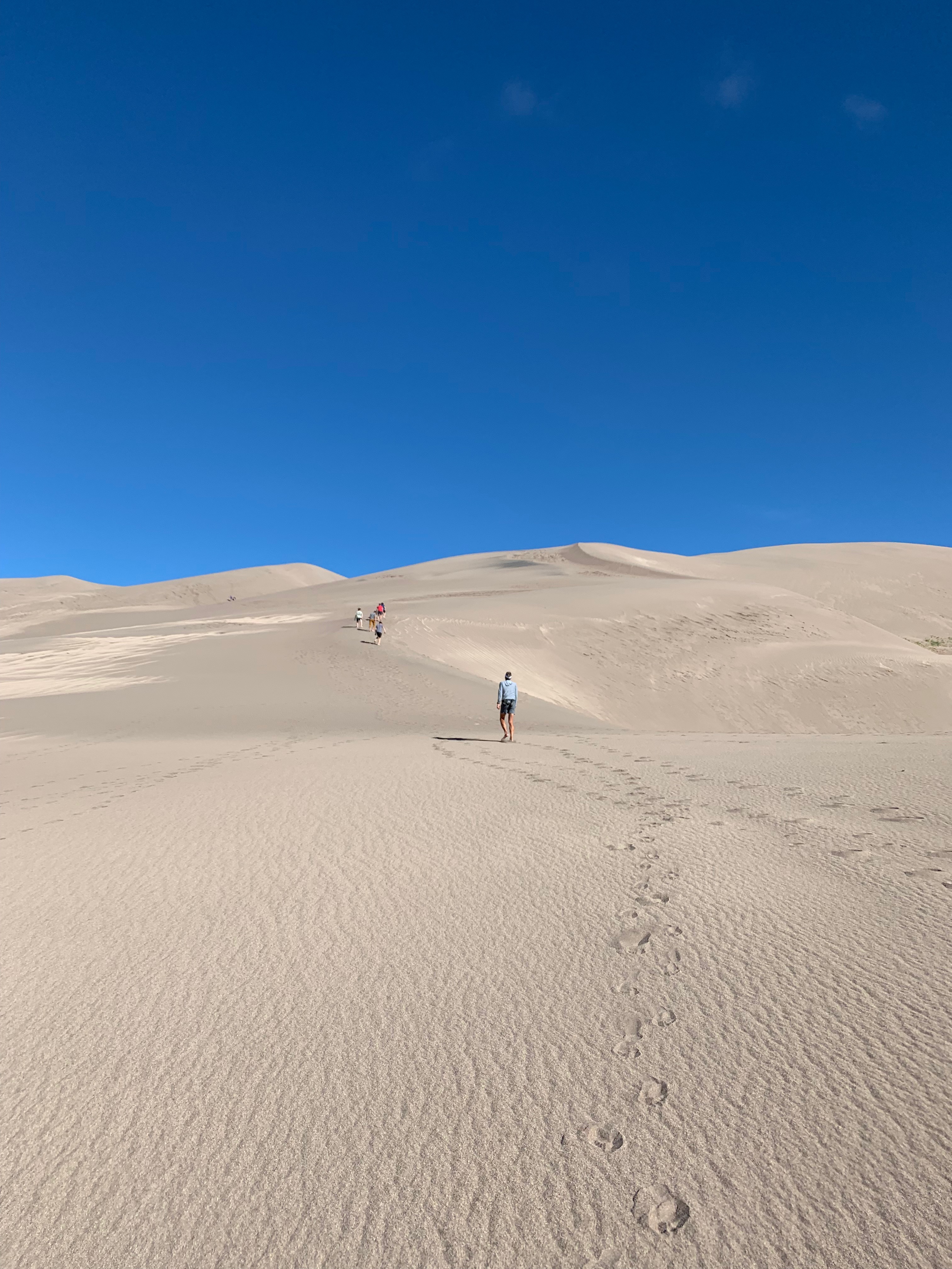
The dune is a fascinating ecosystem of recycled sand that gets kicked up by high southwesterly winds that push sand up east against the Sangre de Cristo Mountains. During storms, the wind shifts in the opposite direction pushing the sand back west. This back and forth forces the sand upward, creating the dunes. It’s suggested that there really isn’t any “new” sand, just the same old sand being pushed around by the wind.
Medano Creek runs at the base of the dunes and is used as a “beach” by the locals. While there, we saw hundreds of families set up beach toys and pop-up tents to spend the day at the creek. It’s very shallow but can run strong and cold. You can rent sandboards and sleds at the visitor center for sand surfing and sledding.

The Beach
Another worthwhile side hike is to Zapata Falls. This 30′ waterfall flows into a narrow crevasse south of Great Sand Dunes National Park. Depending on where you park it’s either a short .4-mile up to 4-mile hike to the falls with the last 400′ through freezing cold water. Take a hiking pole for stability in the water and prepare for the biggest brain freeze you’ve ever experienced!


Brain freeze!

We could only see a small portion of the falls
The falls are not completely visible from…well anywhere. Even after hiking through the creeks to the base of the falls we could only see the small bottom portion. A bit disappointing but still glad we did it.
Buena Vista, CO (Elevation: 7,965’)
We made a stopover in Buena Vista CO on our way to Denver for the Outdoor Retail Show. From the moment we rolled into “BV” (as the locals say) we were in L.O.V.E. Getting its start from rich agriculture and mining, BV is a flourishing summer tourist destination on the Arkansas River Headwaters.

The Arkansas River in Colorado

The Midland Trail along the Midland Railroad rails to trails
Many of the downtown buildings date back to the 1880-1890s, giving this town an amazing sense of history and resilience. Right from downtown, you have miles of mountain biking and hiking trails along the Arkansas River. And the river offers kayaking, white water rafting, and paddleboarding.
After running the Midland Trail, the old Midland Railroad line, we had an amazing lunch at the Simple Café downtown.

Adorable Buena Vista from the Midland Trail
After studying the very expensive house market we decided that we might plan to spend 3 months here next summer at one of the local RV parks. Monthly RV Park rates average about $500-700/month, much cheaper than rent or mortgage payment in this pricey little mountain town.
Salida, CO (Elevation: 7,083’)
After a week’s stay at Bear Creek County Park in Denver, we headed back through BV on our way to Salida. We were attending the Xscapers 4thof July Convergence. Salida is another neat little Colorado mountain town with all the charm that comes with the wild west of the 1880s.

Xscaper shenanigans in the Salida 4th of July parade

Downtown Salida
After the convergence at the Chaffee Fairgrounds, we moved 5 miles down the road to the Shavano BLM area. Once relocated we used this location to bag our first two Colorado 14’ers…Mt. Shavano (14,231’) and Tabeguache Peak (14,162’).

Our beautiful forestry campsite
This was a brutal Class 2, 12-mile round trip with 5,600 feet elevation gain that took us 9 hours to complete. Tabeguache Peak is only accessible via Mt. Shavano, so if you are going to do one you might as well do both.

The trail to these two peaks is a relentless steep uphill battle that gets no reprieve what so ever. No flat strolls through pretty little meadows. No rollers for a bit of recovery. No switchbacks to easy the steep grade. Just straight uphill…for 5 long hours. The final approach to both mountains are scrambling over bolder fields with no definitive trail and patches of snow.
But as tough as the uphill slog was, the downhill was just as painful, slow and rocky. It was a long day and I’m glad to be in enough shape to decide on any given day to hike a 14’er!
Next up, Mt Elbert, the highest peak in Colorado.
Flagstaff Boonies and Peaks
Posted by Deb in Arizona, Boondocking, Bucket List, Full Time RV, Highest Peaks, Hiking, Uncategorized on October 25, 2015

Welcome to 7,000 ft…catch your breath!
-
- Clingers in the nicest way!
-
- Dinner with friends…we really like these two

The trail calls and I must go!

Agassiz Peak from Humphreys Peak Trail. San Francisco Mountains.
-
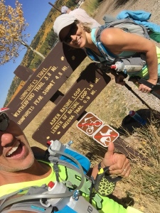
- Humphreys Peak Trailhead…here we go!
-
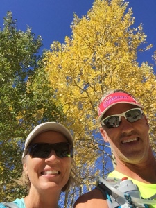
- Aspens in full glow!
Jeff, Sam and I left Humphreys Peak TH from the Arizona Snow Bowl following a smooth trail that took us through a field of glowing aspens. But the smooth trail was short lived as we quickly entered a hole in the tree line and the trail quickly turned rugged and rocky. It was an ankle turner almost the entire way and Jeff rolled his and launched himself over the side of the trail, only to be stopped by a small tree. That. Was. Close!

Navigating the rough trail

View from Mt. Humphreys with aspens far below and controlled burn in the distance!

Sunset from Mt Humphreys TH set off by a controlled burn in the distance

This is how we roll…me driving and the boys sleeping!
