Archive for December, 2015
What Happened?
Posted by Deb in Uncategorized on December 12, 2015
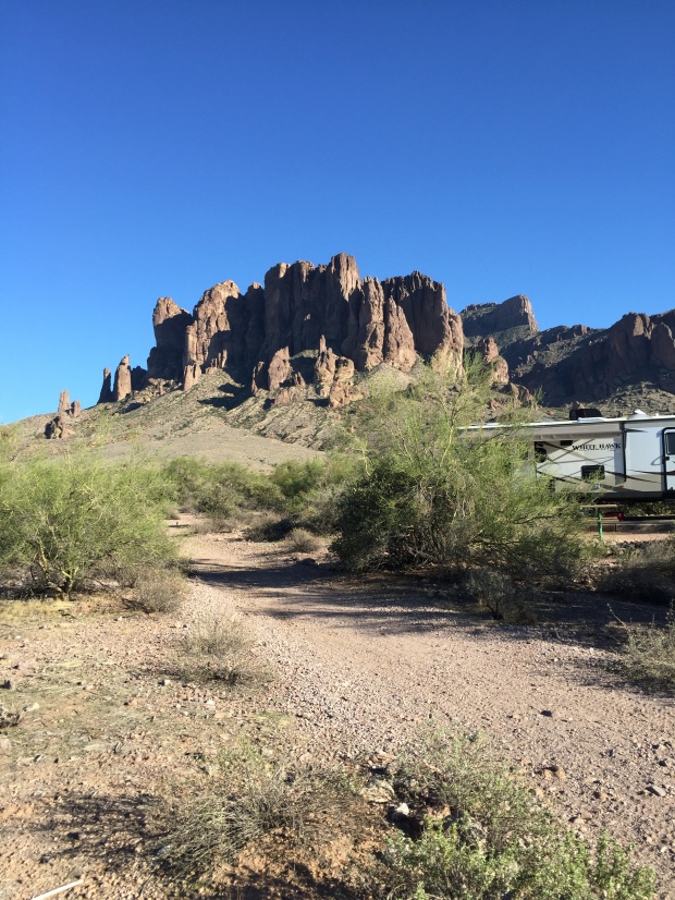
Superstition Mountains
I really like the Phoenix area.
Not necessarily the traffic, noise or crowds. But I do like the warm winter weather and broad mountain views and tons of hiking right in the heart of the city.
Last year Jeff and I spent a couple of weeks driveway surfing in Mesa leading up to Ironman Arizona. Thanks to a high school buddy from California, we were hooked up with an awesome family who had full RV hookups right in their driveway. The driveway surrounded by orange, grapefruit and pomegranate trees make for a very private RV’ing experience…better than any RV park in the area.
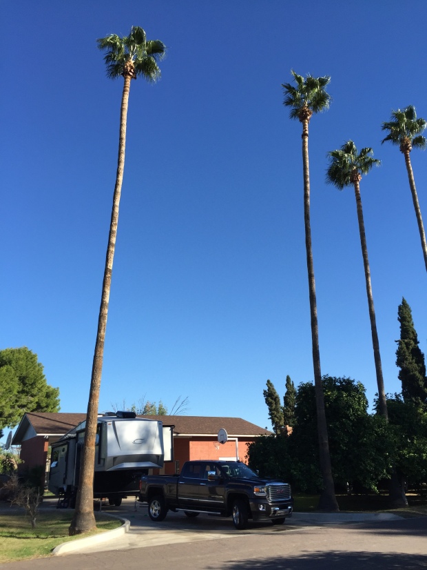
Sweet “camping” spot in Mesa
We contacted our host family again and they were happy to let us stay again this year for the same reason.
We had an invitation by our friend Marshall to a night hike the day we rolled in. Quite frankly, I didn’t want to go after a day of travel. But Jeff talked me into it…and I am so glad he did.
We met a “meet up” group at South Mountain for a 6-7 mile hike just as the sun was setting in the horizon. The views are not your typical forest or fauna but of broad city views that begin to twinkle with each passing minute. Although, I did hear that you WILL experience snakes here in the summer!


The 1000’ elevation gain was tough and the footing tricky, but my first night hiking experience is one that needs to be repeated for sure!
Jeff happened to roll his ankle for the 4th time in a month. So when I started talking to Marshall about hiking the infamous Flat Iron in the Superstition Mountains, Jeff decided it was best to stick to flat land training leading up the his race. Marshall and I made arrangements to meet Sunday for the hike.
So here is where things got very interesting!
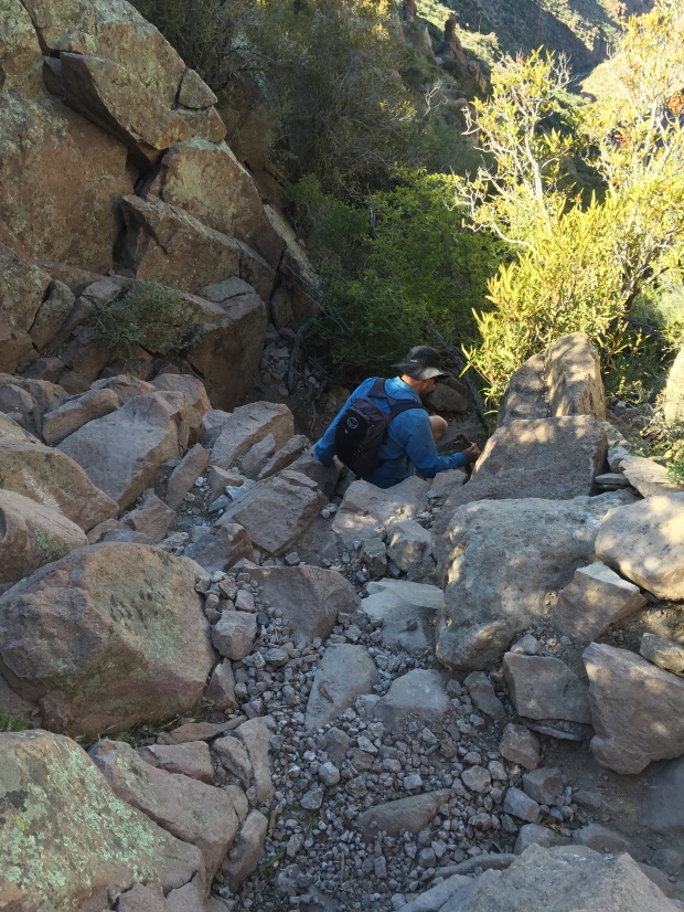
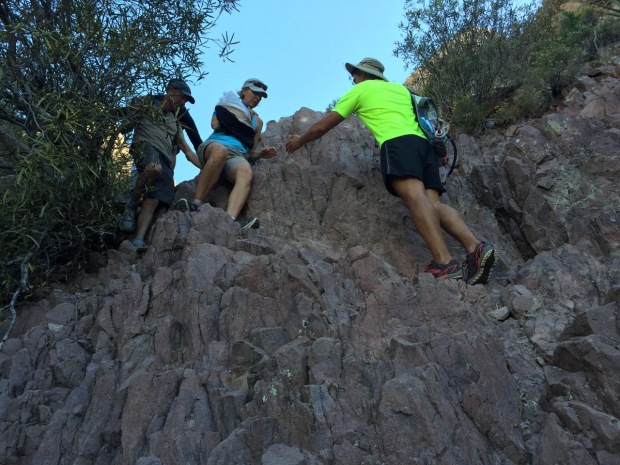
Flat Iron by way of the Siphon Draw trail is about a 6 mile round trip hike that will challenge the best of hikers. Overall elevation gain is around 2600’ and not for the faint of heart. You need strong legs AND arms in order to pull yourself up over boulders, slick slabs and at times, shear vertical climbs. Lots of bouldering and scrambling here and good shoe treads are a must!
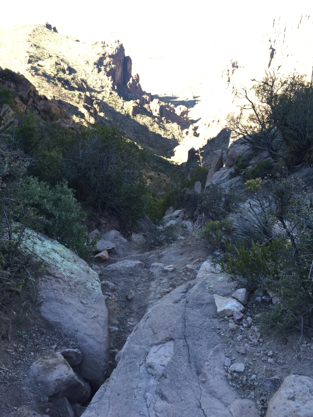
The rugged Siphon Draw Trail
It’s very common to see hikers wearing gloves to protect their hands, but hiking poles are of no use…even dangerous (IMHO).
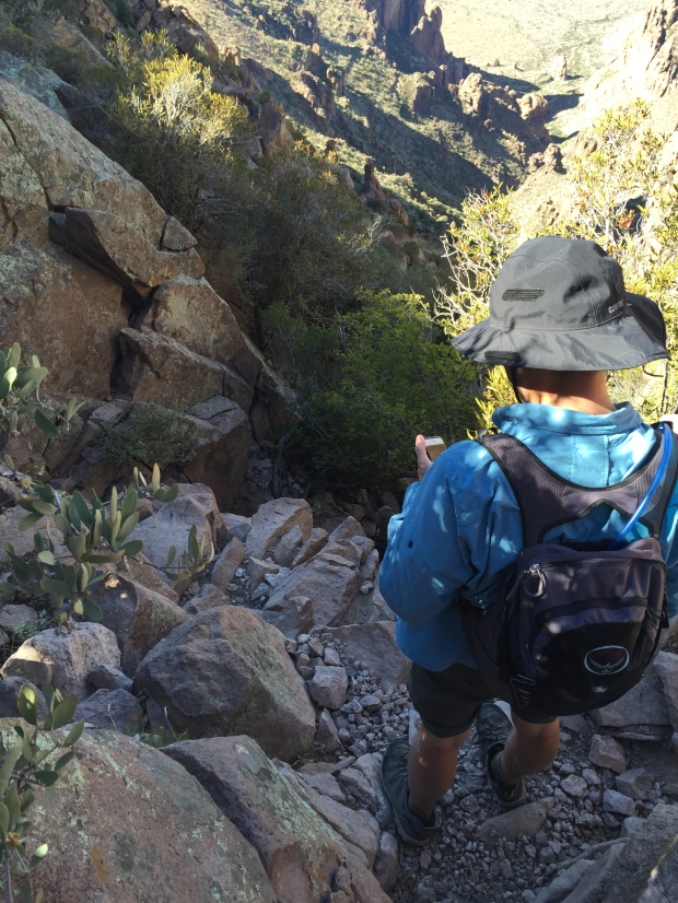
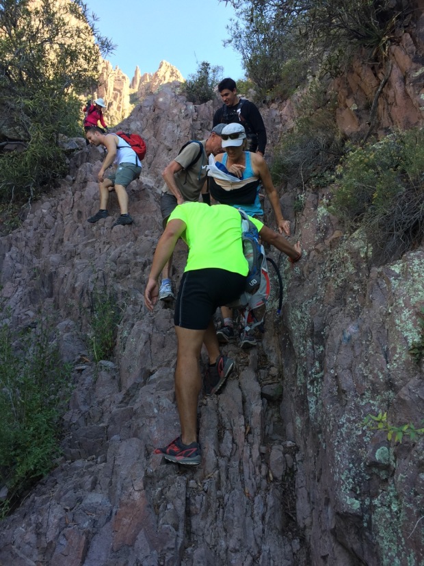
Marshall and I headed out about 9AM with water and snacks. Marshall carries a pretty big pack and when I made fun of him questioned him about what all he carries, he just told me, “stuff I might need”. Well ok then!
We made the hard scramble to the top and appreciated the spectacular 360 views over jerky and trail mix. We were surprised by the amount of people that were on top of the mountain…probably 75-100. All of us enjoying our accomplishment!


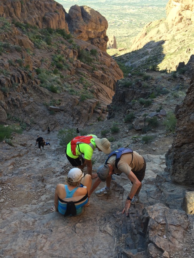
But as I have said before, getting to the top is only half the hike. Especially this one! Marshall and I headed back down the trail, carefully choosing our line of descent. I tend to get a little overly cautious at times like these ever since I had back surgery 3 years ago. With screws and rods in my spine there is always a bit of carefulness in the back of my mind.
Marshall studying the best line…or is he looking at his phone?
Starting down the mountain
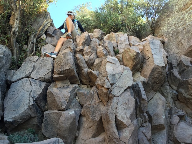
Scrambling just before…
But as I stepped down on a boulder my feet slid out to the left and I toppled over another boulder on the right and I landed with a thud about 4’ below. My first thought was for my back as I lay there assessing the damage.
Surprised, I didn’t feel pain anywhere! WOW! Could I have just dodged a hiking bullet? I guess I did! Yahoo, yippee, skippy!! But when I told myself to get up…I couldn’t move. As hard as I told my body to get up, something was holding me to the ground.
And then I saw it. My right wrist the shape of a Z.
Now there are a lot of things that can run through one’s head in times like these and my initial thought was that I have to get down this mountain before the pain kicks in! But when I went to stand the pain hit and my wobbly legs lowered me back to the ground. How on earth was I going to get down this mountain?
Within minutes (just after he almost lost his cookies!) Marshall opened up his big backpack and pulled out an enormous First Aid kit and started unpacking everything we would need to stabilize a fracture. We were instantly surrounded by other folks who were asking what they could do to help.
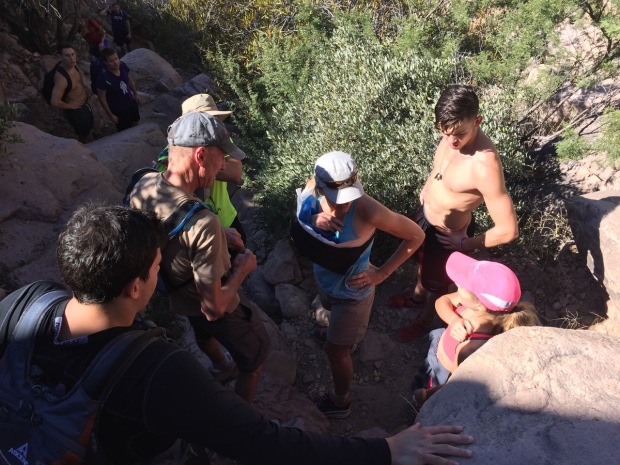
Rallying the troops to strategize how do get down
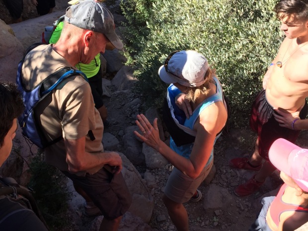
We tried to get the splint on but I couldn’t stand the pressure to mold it to my arm. So another hiker, Andrés, offered up his ice filled camelback bladder and we wrapped that around my wrist with gauze. I had instant relief from the numbing ice!
Then we wrapped my entire arm around my body to further stabilize it.
Between 3 other hikers I had 1000mg of Ibuprofen in my system and we started hiking down the mountain.
While I was getting bandaged up another hiker called 911. Since the initial word was that I couldn’t walk (due to the pain), the sheriffs department relayed that I had a broken leg AND arm and a helicopter was dispatched.
Andres giving me a hand in front and Harold in back
I have to admit, when I heard about the helicopter I had visions of a $15,000-$20,000 bill landing in my mailbox. So as soon as I was stabilized and able to walk we called off the joy ride! Search And Rescue was dispatched instead.
For 4 more hours, between Marshall, Andrés and another hiker Harold, every line and every foot placement was deliberately chosen. I spent most of the hike scooting on my bum, the trail being too steep for my wobbly legs.
Every step was planned
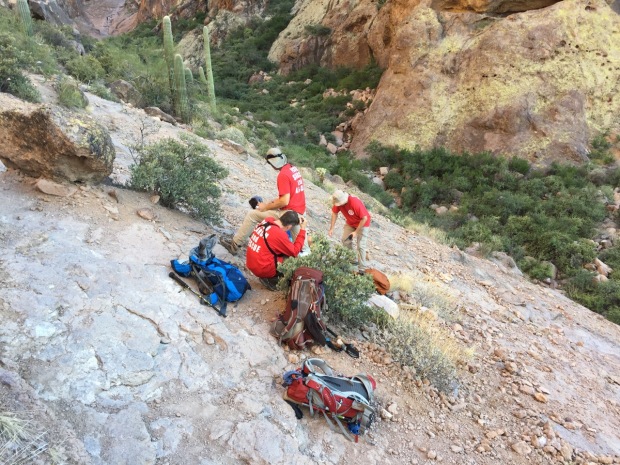
Finally reaching search and rescue
(Funny side note…after 30 minutes of Harold helping we looked at each other and realized that we had met on La Luz hiking trail in Albuquerque just a few weeks before!)
Three hours into the slow descent we were finally met by search and rescue. They re-bandaged my wrist (OUCH!) and started checking my vitals every 5 minutes. The EMT felt I was going into shock and they called for an Ambulance to be waiting to take me to the hospital. Another hour later we were finally down.
Hallelujah!


Jeff was waiting for me with the Sheriff and ambulance. I didn’t know it but Marshall had called his parents in Apache Junction and made arrangements for them to pick Jeff up and take him to the trailhead. He put on his running shoes when he got there but the Sheriff told him to take them off. He didn’t want another “helper” up there getting in the way.
Also, I asked Marshall to communicate to Jeff on top of the mountain that I would need surgery and to start making some calls to find out who and where we should go.
I had been pretty stoic and tried to be in good humor on our scoot down the mountain. But on the way to the hospital my mind now had nothing else to focus on but the pain. By the time I hit the ER I was crying hysterically from the experience and the pain…all the while apologizing to my caregivers for how bad I must have smelled!
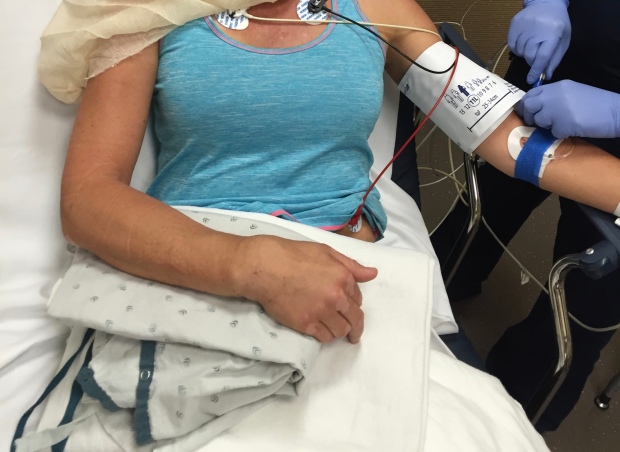
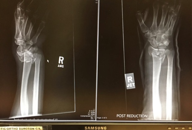
They x-rayed my wrist, knocked me out and reduced the fracture with the help of 4 others holding me down. Thankfully, through local friends, we were scheduled with an incredible hand surgeon the next day for an evaluation…and surgery followed 2 days later.
Doc told Jeff I “smoked it”
Since this experienced happened I am in awe and so grateful of others who got me down that mountain (Marshall, Andrés, Harold and the 4 search and rescuers), those who provided transportation for Jeff (Marshall’s parents), friends who made medical connections (Paul and Laura), our host family who made me hot soup and home made bread (the Brooks family), Dr. Spencer Stanberry who has a passion for wrists and the nursing staff at both the hospital and surgery center (all top notch).
We will be stationed here in Mesa for 8-12 weeks of PT, which I started two weeks after surgery. I consider myself blessed to have had such support & prayers during such a tough experience.
I can only hope that I can pay it forward someday!
And Marshall…I will never make fun of your big backpack again!
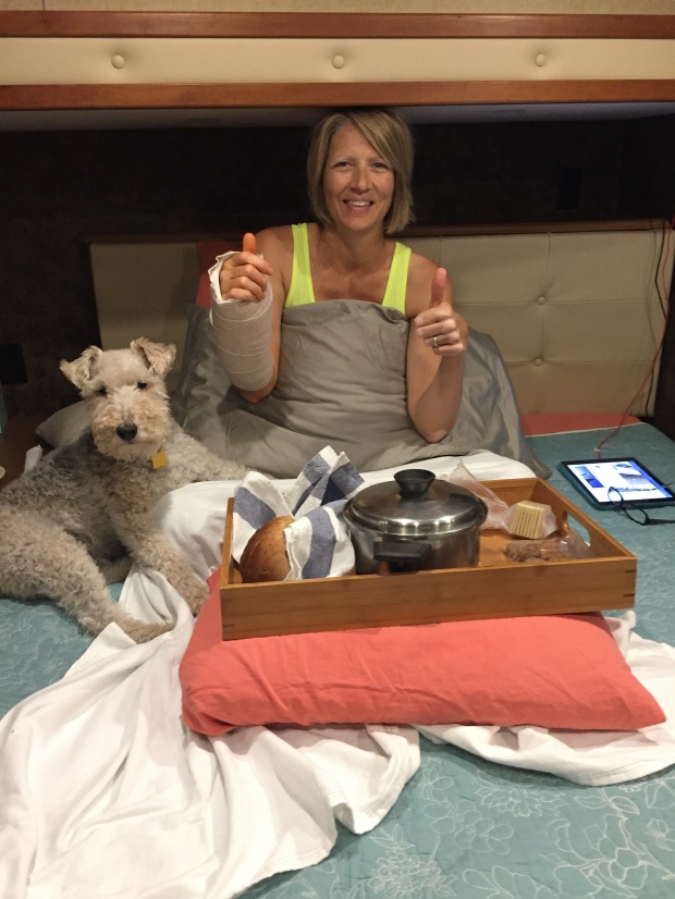
On the mend with soup and puppy therapy
Migration South
Posted by Deb in Arizona, Boondocking, Destinations, Full Time RV, Hiking, Sam-a-lama-ding-dong, Uncategorized on December 9, 2015

It’s been a while since I posted on my blog. My last entry was about our epic hike at the Grand Canyon back in October. I started typing my next post when something went drastically wrong leaving me unable to keep typing!
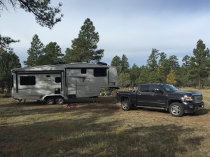
After Jeff and I left the Grand Canyon we headed back to Flagstaff where we dispersed camped at one of our favorite spots by Lake Mary. The alpine forest, miles of forestry roads to get lost on and hiking on the Arizona trail are some of my favorite reasons to camp here.
We did try a new location just north of Flag after calling the Forestry Department. “There are plenty of camping spots up there”, they said. “Good access”, they said. But after an hour of narrow roads and only two camp spots that were impossible to get in to, we decided to “go with what we know” and pushed on to Lake Mary. Trouble was, we were up a creek without a paddle. Or in RV’ing terms…down a narrow road without a turnout! After carefully backing up a 1/2 mile we finally swung the 5’er into to weeds to get turned around.

Contemplating how to get this thing turned around
I’ve found the most challenging parts of dispersed camping is that you never know what you are getting you and your rig into.
One persons opinion of “plenty of clearance” is usually nowhere close to the reality of our specific rig. If someone has wedged a 30,000lb forty-foot motorhome in a spot, then I have a bit more confidence in their recommendations. But NEVER take the word of a non-RV’er unless you want to find out what serious heartburn is like.
Lake Mary works out well for a Triathlete in training. The pool at the college is an easy 10 miles away and Lake Mary Rd is a major thoroughfare for cyclists and runners. Perfect for Jeff to continue some high altitude training for the Arizona Ironman.

The Arizona trail just steps from our campsite
While Jeff trained, I hiked a portion of the Arizona trail just steps from our camping spot.
The Arizona Trail is a National Scenic Trail that runs from the border of Mexico to the Utah border, traversing the North/ South length of Arizona for 800 miles. It was officially opened December 16, 2011.
The section I hiked was near the Lowell Observatory and Marshall Lake. It was not particularly scenic with primarily flat hiking through cattle fields.
-
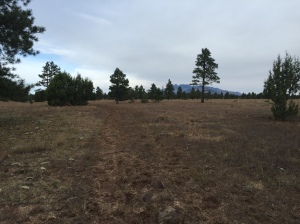
- Not much to see here folks
-
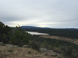
- Lake Mary…the only scenic part of my hike
Sam dog is a great little hiker as he follows the trail very well. If I come to a part where I’m not sure where the trail is I just follow him…he knows every time. But he did step off the trail briefly and ended up with a big cholla ball stuck to his front leg. When that happens he tries to keep going because he HATES when I pull those dang things out. He hollers like you wouldn’t believe and comically when I pulled this one out to his great displeasure it flung out and stuck his back leg, doubling the experience. Once we start moving again all is forgiven and Sam stayed on the trail.
-
- Our free alpine camping at Lake Mary
-
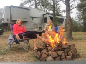
- One of the rare moments we actually sit by a campfire
We decided to pull out of Flagstaff a day early since wet weather was coming in and we were on soft ground with low batteries. So we pulled up the jacks and headed to Sedona.
There is free dispersed camping available west of town on Forestry Road 525. We camped here last year and learned if you travel about 5 miles back on the washboard roads you are treated with some spectacular views and close hiking trails. We had some great days of sun and got the batteries charged back up to 100%.

Scene out our front door

Sam tearing it up and turning a nice shade of Sedona red
-
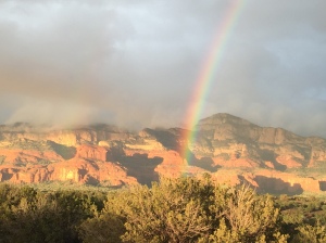
- Rain and rainbows
-
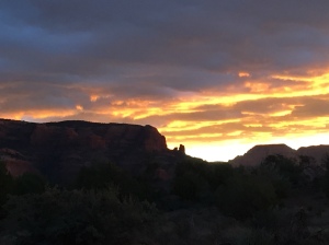
- Sunrises and sunsets
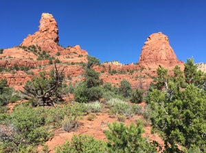
Sedona is incredibly beautiful and is one of my top 5 places to see thus far in our travels.
Hiking is spectacular in Sedona, but it is also very popular. If you are looking for a get away from it all experience you will have to travel a little further out of town. But what I love the most about hiking here is the sandy red soil contrasted with the green scrub bushes, Junipers, Arizona pines and Pinon Pines. Mix that in with the scent of toasted pine needles on the trail, red rock views at every turn and warm sun and you have yourself hiking nirvana!
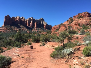
After paying a $5 day use fee Sam and I set off on Soldier Pass Trail. This trail is a great loop with incredible views of the red rock formations, slabs and the city. We hiked the trail counterclockwise; since I have hiked this trail clockwise a couple of times before.

Trail dog Sam leading the way
The initial accent takes to you to some red slabs with wide-open views. It’s a great spot for a picnic and photos before heading up natural stairs towards Brin Mesa. At the top of Soldier pass the trail flattens out and turns from red to a light sand color. I wanted to take the Brin Mesa tail for an out and back, to log some additional miles.
The Brin Mesa trail takes a steep decent back down the other side of the mountain. I always laugh at myself after descents like these because my mind automatically thinks about having to hike back up. Like the Grand Canyon my mind blows up the imagined accent to be much more difficult than it actually is. Then I’m always surprised when I get to the top wondering if I still have “the hill” to go. Silly self!
I mistakenly thought the Brin Mesa trail would actually take me to a mesa. But once I ran into a forestry road, my turn around point, I was informed by other hikers that the actual mesa was off some other offshoot from Soldier Pass. I’ll have to catch that one the next time.
-
- Stunning contrast of color
-
- Slabs near “The Sinkhole”
Back on Soldier pass, Sam and I started down the west side of the mountain back into red soil. It was getting hot by now and my two bottles of water were starting to get low. Thankfully we reached more slabs on this part of the trail. The slabs have some natural pools that form from bowl shaped indentations in the rocks. These pools had collected fresh water from recent rains, which Sam found refreshing for consumption and wading in, leaving the remaining water in the bottles for me.
Closer to the west side Soldier Pass Trailhead near “The Sinkhole” it gets pretty noisy from jeep tours and ATV’s that are allowed on the trail here. We jumped off Soldier Pass at this point and took the Jordon trail heading east back to our parking lot.
Sam found another pool that was pretty murky and large and waded in to cool his dogs. Problem was it was very deep. To both our surprise he disappeared underwater only to bob back up sputtering. He wasn’t too thrilled about going scuba diving but he was super frisky after that. I guess his bath really cooled him down.

Sam cooling down in a shady spot
We ended up hiking 8.5 miles over 3 hours…what a great time!
After a week in Sedona rain and snow moved in. It was stunning to wake up to a ring of white snow on the red rocks at the higher elevations. But to maintain our shorts and flip flop temps we moved on to Phoenix/Mesa…. where things turned very interesting!

What the heck!
