Posts Tagged Soldier Pass
Migration South
Posted by Deb in Arizona, Boondocking, Destinations, Full Time RV, Hiking, Sam-a-lama-ding-dong, Uncategorized on December 9, 2015

It’s been a while since I posted on my blog. My last entry was about our epic hike at the Grand Canyon back in October. I started typing my next post when something went drastically wrong leaving me unable to keep typing!
After Jeff and I left the Grand Canyon we headed back to Flagstaff where we dispersed camped at one of our favorite spots by Lake Mary. The alpine forest, miles of forestry roads to get lost on and hiking on the Arizona trail are some of my favorite reasons to camp here.
We did try a new location just north of Flag after calling the Forestry Department. “There are plenty of camping spots up there”, they said. “Good access”, they said. But after an hour of narrow roads and only two camp spots that were impossible to get in to, we decided to “go with what we know” and pushed on to Lake Mary. Trouble was, we were up a creek without a paddle. Or in RV’ing terms…down a narrow road without a turnout! After carefully backing up a 1/2 mile we finally swung the 5’er into to weeds to get turned around.

Contemplating how to get this thing turned around
I’ve found the most challenging parts of dispersed camping is that you never know what you are getting you and your rig into.
One persons opinion of “plenty of clearance” is usually nowhere close to the reality of our specific rig. If someone has wedged a 30,000lb forty-foot motorhome in a spot, then I have a bit more confidence in their recommendations. But NEVER take the word of a non-RV’er unless you want to find out what serious heartburn is like.
Lake Mary works out well for a Triathlete in training. The pool at the college is an easy 10 miles away and Lake Mary Rd is a major thoroughfare for cyclists and runners. Perfect for Jeff to continue some high altitude training for the Arizona Ironman.

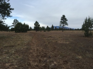
The Arizona trail just steps from our campsite
While Jeff trained, I hiked a portion of the Arizona trail just steps from our camping spot.
The Arizona Trail is a National Scenic Trail that runs from the border of Mexico to the Utah border, traversing the North/ South length of Arizona for 800 miles. It was officially opened December 16, 2011.
The section I hiked was near the Lowell Observatory and Marshall Lake. It was not particularly scenic with primarily flat hiking through cattle fields.
-
- Not much to see here folks
-
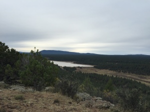
- Lake Mary…the only scenic part of my hike
Sam dog is a great little hiker as he follows the trail very well. If I come to a part where I’m not sure where the trail is I just follow him…he knows every time. But he did step off the trail briefly and ended up with a big cholla ball stuck to his front leg. When that happens he tries to keep going because he HATES when I pull those dang things out. He hollers like you wouldn’t believe and comically when I pulled this one out to his great displeasure it flung out and stuck his back leg, doubling the experience. Once we start moving again all is forgiven and Sam stayed on the trail.
-
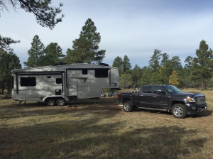
- Our free alpine camping at Lake Mary
-
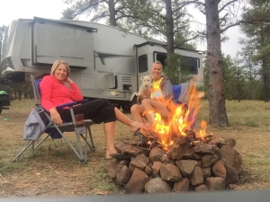
- One of the rare moments we actually sit by a campfire
We decided to pull out of Flagstaff a day early since wet weather was coming in and we were on soft ground with low batteries. So we pulled up the jacks and headed to Sedona.
There is free dispersed camping available west of town on Forestry Road 525. We camped here last year and learned if you travel about 5 miles back on the washboard roads you are treated with some spectacular views and close hiking trails. We had some great days of sun and got the batteries charged back up to 100%.

Scene out our front door

Sam tearing it up and turning a nice shade of Sedona red
-

- Rain and rainbows
-
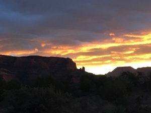
- Sunrises and sunsets
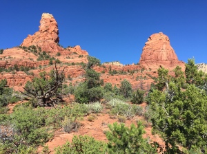
Sedona is incredibly beautiful and is one of my top 5 places to see thus far in our travels.
Hiking is spectacular in Sedona, but it is also very popular. If you are looking for a get away from it all experience you will have to travel a little further out of town. But what I love the most about hiking here is the sandy red soil contrasted with the green scrub bushes, Junipers, Arizona pines and Pinon Pines. Mix that in with the scent of toasted pine needles on the trail, red rock views at every turn and warm sun and you have yourself hiking nirvana!
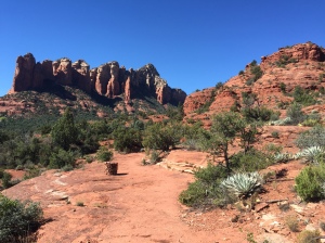
After paying a $5 day use fee Sam and I set off on Soldier Pass Trail. This trail is a great loop with incredible views of the red rock formations, slabs and the city. We hiked the trail counterclockwise; since I have hiked this trail clockwise a couple of times before.

Trail dog Sam leading the way
The initial accent takes to you to some red slabs with wide-open views. It’s a great spot for a picnic and photos before heading up natural stairs towards Brin Mesa. At the top of Soldier pass the trail flattens out and turns from red to a light sand color. I wanted to take the Brin Mesa tail for an out and back, to log some additional miles.
The Brin Mesa trail takes a steep decent back down the other side of the mountain. I always laugh at myself after descents like these because my mind automatically thinks about having to hike back up. Like the Grand Canyon my mind blows up the imagined accent to be much more difficult than it actually is. Then I’m always surprised when I get to the top wondering if I still have “the hill” to go. Silly self!
I mistakenly thought the Brin Mesa trail would actually take me to a mesa. But once I ran into a forestry road, my turn around point, I was informed by other hikers that the actual mesa was off some other offshoot from Soldier Pass. I’ll have to catch that one the next time.
-
- Stunning contrast of color
-
- Slabs near “The Sinkhole”
Back on Soldier pass, Sam and I started down the west side of the mountain back into red soil. It was getting hot by now and my two bottles of water were starting to get low. Thankfully we reached more slabs on this part of the trail. The slabs have some natural pools that form from bowl shaped indentations in the rocks. These pools had collected fresh water from recent rains, which Sam found refreshing for consumption and wading in, leaving the remaining water in the bottles for me.
Closer to the west side Soldier Pass Trailhead near “The Sinkhole” it gets pretty noisy from jeep tours and ATV’s that are allowed on the trail here. We jumped off Soldier Pass at this point and took the Jordon trail heading east back to our parking lot.
Sam found another pool that was pretty murky and large and waded in to cool his dogs. Problem was it was very deep. To both our surprise he disappeared underwater only to bob back up sputtering. He wasn’t too thrilled about going scuba diving but he was super frisky after that. I guess his bath really cooled him down.

Sam cooling down in a shady spot
We ended up hiking 8.5 miles over 3 hours…what a great time!
After a week in Sedona rain and snow moved in. It was stunning to wake up to a ring of white snow on the red rocks at the higher elevations. But to maintain our shorts and flip flop temps we moved on to Phoenix/Mesa…. where things turned very interesting!

What the heck!
